Tuesday 31 March 2015

Top 5 Ways Job-Seekers Blow it

Courtesy of Careers24.com

So, to improve your chances of success follow these 5 golden rules:
  1. Follow the recruiter's instructions
  2. Ensure that you possess the necessary qualifications and experience
  3. Do not try to short-cut the system
  4. Conduct yourself professionally
  5. Do a spell check on your cv

Friday 13 March 2015

Get involved in International Map Year 2015 - 2016


Maps are at the core of geospatial, and we’re now into the International Map Year 2015 - 2016.

From the official website: The International Map Year (IMY) is a worldwide celebration of maps and their unique role in our world.  Supported by the United Nations, IMY provides opportunities to demonstrate, follow, and get involved in the art, science and technology of making and using maps and geographic information. The ICA expects that all ICA member countries will participate in order to give their citizens a broader knowledge of maps – how they are produced and used for many purposes in society.
Another goal is to give school children and university students an opportunity to learn more about cartography and about its neighbouring geospatial sciences geodesy, photogrammetry, remote sciences and surveying. ICA has about 80 national members, and the UN will be helpful in establishing contact with all other countries in the world, so that International Map Year will be celebrated worldwide.”

Refer to their website for details on how you can participate http://internationalmapyear.org/

Proceed to the ebook of the World of Maps

Wednesday 11 March 2015

Satellite-based fire information tool

Given the recent Cape Fire and now the Jonkershoek blaze which is almost on our doorstep, it is understandable that wherever you go, everyone is discussing the fire, so it's reassuring to discover that the CSIR has developed a fire-detection system.  The application of remote sensing coupled with cell phone technology for alert messaging in the Advanced Fire Information System (AFIS) is the first of its kind in the world!

 
The Jonkershoek Fire as depicted on AFIS's website


This real-time tool enables to clearly see just how beneficial to the authorities this can be.


One can also view the extent of the Cape Fire which
was reported globally.

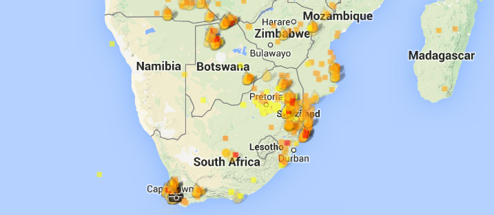
Active fires detected by the MODIS Satellite
For more information visit the website http://www.afis.co.za/

Pictures courtesy of afis